Octavian Thor Pleter and Cristian Emil Constantinescu, and Barna Istvan Jakab, University Politehnica of Bucharest, 060042 Bucharest, Romania
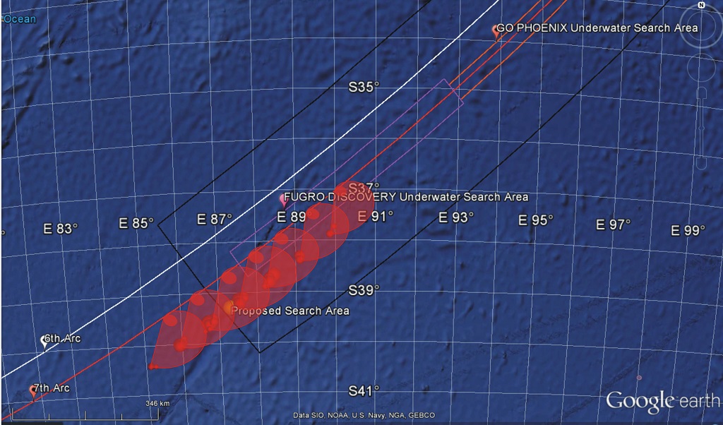
Abstract: In the aftermath of the disappearance of the Malaysian 370 (MH370) flight in March 2014, new positioning methods were employed to establish the search area. In the absence of all other positioning technologies (Transponder, Radio communications, Radar), these innovative methods are based on the handshake signals between an INMARSAT satellite and the satellite transceiver on board the aircraft. The log of these signals was made public in order for the scientific community to engage in solving the mystery of the MH370 trajectory. The log indicates the delay between the interrogation and response signals, as well as the relative velocity indications, based on the shift of the carrier frequency due to the Doppler-Fizeau effect. This paper puts forward an original, independent and accurate positioning method and allows the calculation of the MH370 trajectory considering the wind vector field that day, the accurate satellite orbit and an accurate model of the Earth (the WGS-84 ellipsoid). The results were compared to other results published, indicating a different final position of the aircraft from the locations of the published search area.
Download full article here.
The article won the Richey Medal 2017 of the Royal Institute of Navigation, London.
ANUNT PRIVIND CAZĂRILE ÎN UNIVERSITATEA POLITEHNICA DIN BUCUREȘTI – AN UNIV 2020-2021
ANUNT PRIVIND CAZĂRILE ÎN UNIVERSITATEA POLITEHNICA DIN BUCUREȘTI – AN UNIV 2020-2021
Ghiduri pentru activitati digitale UPB
Ghiduri pentru activitati digitale UPB
Organizarea studiilor de licenta, masterat si doctorat pentru anul universitar 2020-2021
Organizarea studiilor de licenta, masterat si doctorat pentru anul universitar 2020-2021
Deschiderea anului universitar 2020-2021
Deschiderea anului universitar 2020-2021
Ghid de alocare a temelor pentru examenul de diplomă
<< Ghid de alocare a temelor pentru examenul de diploma >>
Rebuild Education Summit, in partnership with UNESCO
Invitatie - Rebuild Education Summit http://tfaforms.com/4852004 COVID-19 has changed education systems forever. As part of UNESCO’s World Teachers' Day events, please join us on the 9th October at 12:00 BST for the “Rebuild” Education Summit, a global...
Asociatia CESAER (Conference of European Schools of Advanced Engineering Education and Research) a lansat call-ul Best Idea 2021 Competition
CESAER - Best Idea 2021 Competition https://www.cesaer.org/news/best-idea-2021/ Competitia se adreseaza studentilor și doctoranzilor din cadrul universitatilor membre ale asociatiei, incurajand colaborarea in echipa pentru a cauta idei noi si interesante...
Program secretariat 01-23 august 2020
În perioada 01 - 23 august 2020 programul secretariatului este în fiecare miercuri între orele 10 - 14.
International Conference of Aerospace Sciences „AEROSPATIAL 2020”, 15-16 October 2020, Bucharest
"AEROSPATIAL 2020" The National Institute for Aerospace Research "Elie Carafoli" - INCAS Bucharest (under the aegis of the Romanian Academy) invites you to attend at the International Conference of Aerospace Sciences "AEROSPATIAL 2020", 15-16 October 2020,...
8th International Workshop on Numerical Modelling in Aerospace Sciences, “NMAS 2020”
NMAS 2020 Following the measures taken by the Romanian authorities in the current epidemiological context, COVID-19, we inform you that the scientific event of the 8th International Workshop on Numerical Modeling in Aerospace Sciences,“NMAS 2020” 20 - 21...
0 Comentarii