Octavian Thor Pleter and Cristian Emil Constantinescu, and Barna Istvan Jakab, University Politehnica of Bucharest, 060042 Bucharest, Romania
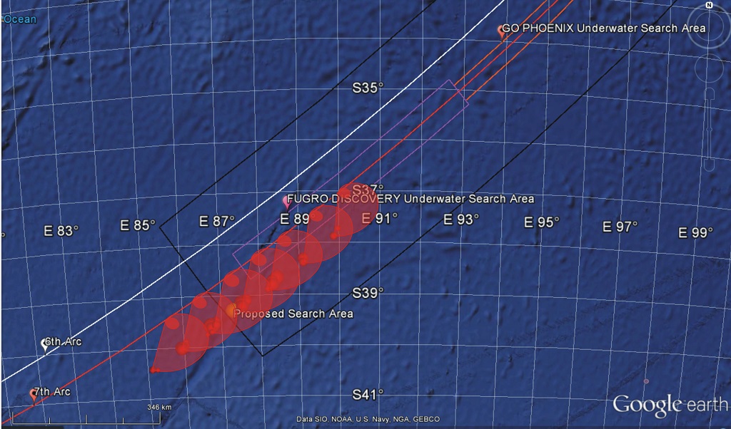
Abstract: In the aftermath of the disappearance of the Malaysian 370 (MH370) flight in March 2014, new positioning methods were employed to establish the search area. In the absence of all other positioning technologies (Transponder, Radio communications, Radar), these innovative methods are based on the handshake signals between an INMARSAT satellite and the satellite transceiver on board the aircraft. The log of these signals was made public in order for the scientific community to engage in solving the mystery of the MH370 trajectory. The log indicates the delay between the interrogation and response signals, as well as the relative velocity indications, based on the shift of the carrier frequency due to the Doppler-Fizeau effect. This paper puts forward an original, independent and accurate positioning method and allows the calculation of the MH370 trajectory considering the wind vector field that day, the accurate satellite orbit and an accurate model of the Earth (the WGS-84 ellipsoid). The results were compared to other results published, indicating a different final position of the aircraft from the locations of the published search area.
Download full article here.
The article won the Richey Medal 2017 of the Royal Institute of Navigation, London.
METODOLOGIE privind organizarea si desfasurarea concursului de admitere la doctorat, an univ. 2021-2022
<< METODOLOGIE privind organizarea si desfasurarea concursului de admitere la doctorat, an univ. 2021-2022 >>
REGULAMENT privind organizarea si desfasurarea concursului de admitere in invatamantul universitar de masterat, an univ. 2021-2022
<< REGULAMENT privind organizarea si desfasurarea concursului de admitere in invatamantul universitar de masterat, an univ. 2021-2022 >>
REGULAMENT privind organizarea si desfasurarea concursului de admitere in ciclul de studii universitare de licenta, an univ. 2021-2022
<< REGULAMENT privind organizarea si desfasurarea concursului de admitere in ciclul de studii universitare de licenta, an univ. 2021-2022 >>
Regulament privind organizarea examenelor de finalizare a studiilor in UPB 2020-2021
<< Regulament privind organizarea examenelor de finalizare a studiilor in UPB 2020-2021 >>
Hotărârea de Senat privind desfășurarea și finalizarea activităților didactice din semestrul II, an universitar 2020-2021 în Universitatea Politehnica din București
<< Hotărârea de Senat privind desfășurarea și finalizarea activităților didactice din semestrul II, an universitar 2020-2021 în Universitatea Politehnica din București >>
Sesiunea de comunicari stiintifice studentesti mai 2021 sectiunea 09- 1,2,3,4
<< FIA_SCSS mai 2021_Sectiunea 09-1, 2, 3, 4 >>
SpaceX and NASA are targeting Friday, April 23 for Falcon 9’s launch of Dragon’s second six-month operational crew mission (Crew-2) to the International Space Station (ISS) from historic Launch Complex 39A (LC-39A) at NASA’s Kennedy Space Center in Florida
<< SpaceX and NASA are targeting Friday, April 23 for Falcon 9’s launch of Dragon’s >>
Hotărârea de Senat privind desfășurarea și finalizarea activităților didactice din semestrul II, an universitar 2020-2021 în Universitatea Politehnica din București
<< HS desfasurare si finalizare activitati didactice sem II, an univ. 2020-2021 >>
Lista Studenti Bursieri Licenta si Master_2020-2021_sem II
<< Lista studenti cu bursa de merit gradul I Licenta 2020-2021 sem II >> << Lista studenti cu bursa de merit gradul II Licenta 2020-2021 sem II >> << Lista studenti cu bursa de performanta Licenta 2020-2021 sem II >>...
Lista provizorie cu studenții selectați să facă parte din grupul țintă al proiectului MAXIMUS pentru Facultatea de Inginerie Aerospațială
<< PVlista-selectie-provizorie_FIA >>
0 Comentarii